CLARENDON!!
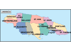

Clarendon is located at the southern side of Jamaica, roughly half-way between the island's eastern and western ends. It is bordered on the north by St. Ann, on the west by Manchester, on the east by St. Catherine and on the south by the Caribbean Sea. It has an area of 461.9 square miles with a population of approximately 212,324. The parish was named by the British in honour of one of England's celebrated chancellors, Lord Clarendon.
The parish is predominantly a wide plain marked by several rivers. Toward its northern end lies the Bull Head Mountain range, which is considered to be the geographical centre of the island. Bauxite, Jamaica's major mineral source, can be found extensively in Clarendon.
Special Attractions
![]() Milk
River Bath
- one of the island's major mineral springs. This spa is famous for the
therapeutic value of its waters.
Milk
River Bath
- one of the island's major mineral springs. This spa is famous for the
therapeutic value of its waters.
![]() Halse Hall Great House
- one of the island's historic houses. The land on which the house stands
was given to an English officer, Major Thomas Halse, in 1655, and was passed
from him to Francis Sadler Halse, who played a leading role in the Maroon
Wars.
Halse Hall Great House
- one of the island's historic houses. The land on which the house stands
was given to an English officer, Major Thomas Halse, in 1655, and was passed
from him to Francis Sadler Halse, who played a leading role in the Maroon
Wars.
![]() Denbigh Aggricultural Show Grounds
- once a year, on the weekend prior to Independence celbrations, a national
Agriculture Show is staged here
Denbigh Aggricultural Show Grounds
- once a year, on the weekend prior to Independence celbrations, a national
Agriculture Show is staged here
![]() Vernam Field
- first car-racing track established in Jamaica
Vernam Field
- first car-racing track established in Jamaica

COPYRIGHT©2006 ALL RIGHT RESERVED MAUREEN B INC